
SEATTLE - Tonight, we're forecasting a rain/snow mix in the lower elevations. Under a heavy band of showers, there could be a brief, light coating of snow on the ground. Whatcom County may have a couple inches on the ground by Christmas morning. But for most of us, it's unlikely we'll accumulate snow overnight (unless the forecast changes). Instead, snow will fall and accumulate throughout the day tomorrow -- especially Christmas evening.
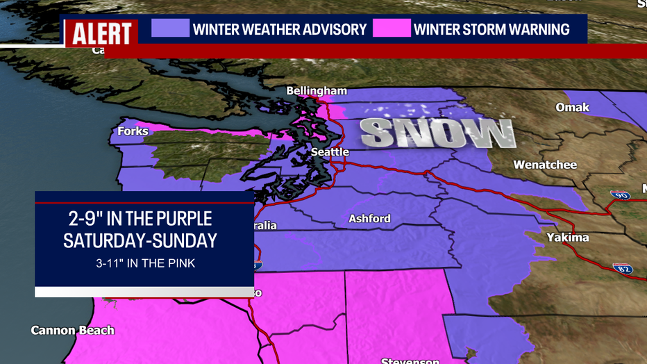
The National Weather Service has issued a Winter Weather Advisory for everyone in purple on the map. Totals could reach anywhere between two to nine inches for everyone included in the advisory. I realize that's a huge range. I think communities like Seattle, Tacoma, Olympia, and Bremerton (Central and South Sound) have the best chance for one to three inches of snow Saturday and Sunday; however, stronger bands of snow could dump locally higher totals -- potential reaching upwards of six inches or more in those areas. One to six inches also looks likely along the Washington coast. Over the Central and North Cascade valleys and passes, five to ten inches are possible.
This snow forecast is particularly challenging because snow won't be widespread and constant this weekend. Rather, snow will be hit-or-miss. Some communities might not get any accumulation at all! Meanwhile, other neighborhoods may get impressive snow totals that make driving a nightmare. It's nearly impossible to predict exactly where the heaviest pockets of snow develop, but models keep hinting that the Northwest Interior and the north slopes of the Olympics may get hit the hardest (in addition to the South Washington Cascades).
Speaking of which, a Winter Storm Warning has been posted for the South Washington Cascades (where 20-30 inches could stack up this weekend!). This warning also includes communities like Bellingham, Mt. Vernon, Camano and Whidbey Islands, Sequim and Port Angeles. These neighborhoods could see as few as three inches, but there's a better possibility for totals nearing eight to 11 inches! The same rule for the advisory applies to the warning; there may lesser or higher totals depending on where the strongest bands develop.
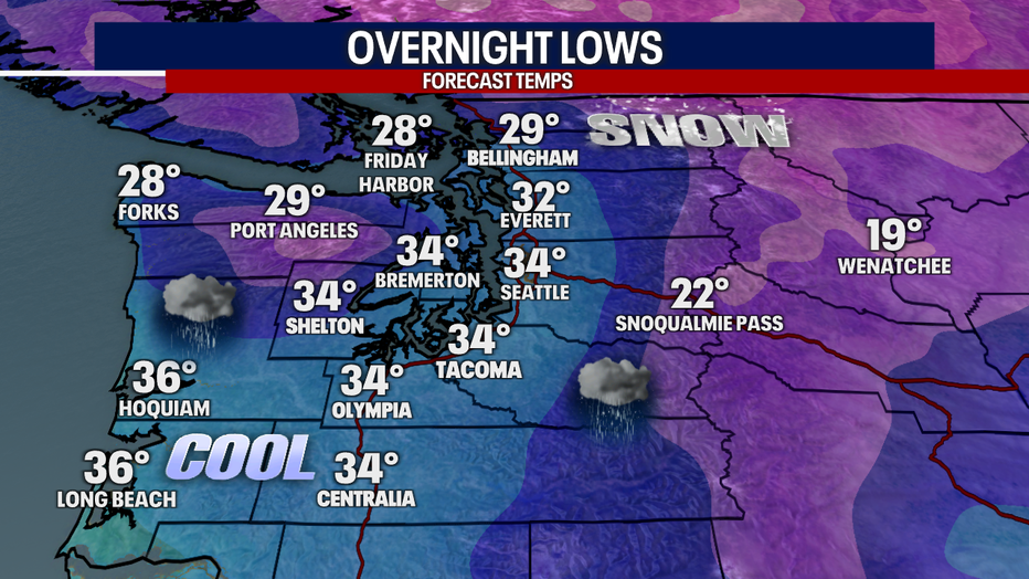
Let's talk about the timeline of snow. Overnight, snow is most likely to fall over the North Coast, Port Angeles and Everett northward to the Canadian border. Meanwhile, there may be a rain/snow mix elsewhere in the Central and South Sound. Look how borderline our temps will be early Christmas morning. If downpours are particularly heavy, it may locally cool the atmosphere to drop temps that otherwise were above-freezing. Bottom line: a rain/snow mix is most likely for most in Puget Sound early Christmas. Whatcom County, the North Coast and the north slopes of the Olympics may start the day with snow, but this forecast is certainly fluid and variable neighborhood-by-neighborhood.
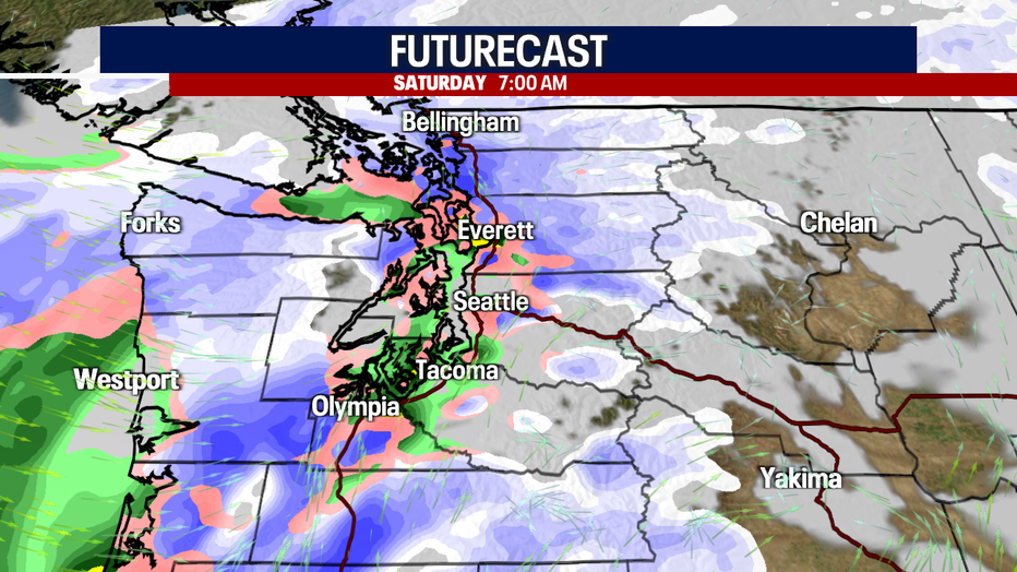
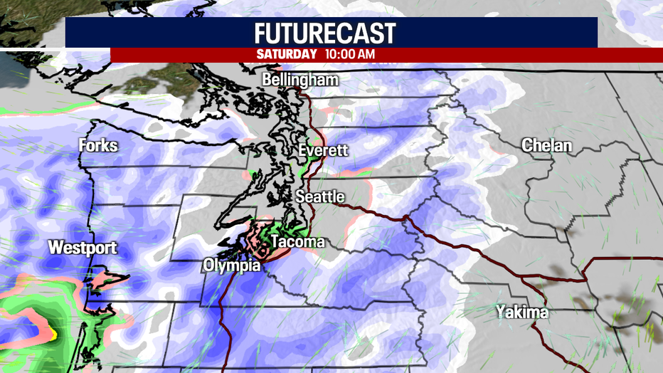
As early as 10 a.m., but as late as 3-4 p.m., rain will convert to snow in Central and South Puget Sound. Snow will be ongoing farther north. Don't be surprised if there are breaks of dry weather tomorrow between the snow showers. The sun may even pop out from time-to-time!
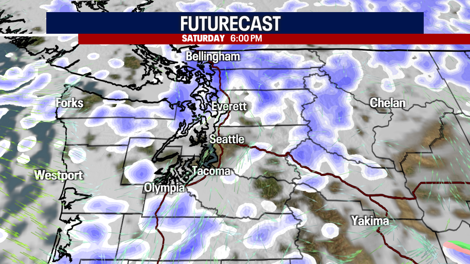
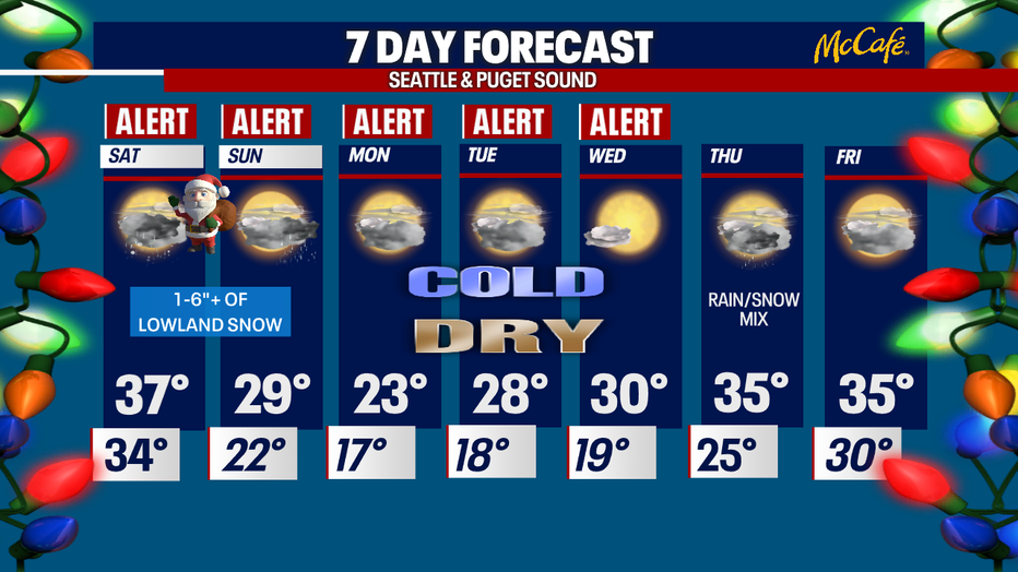
Rounds of snow stay in the forecast through Sunday. Pass travel will be challenging. Western Oregon will also be slammed by exceptionally heavy snow on Sunday. Dry weather returns to Western Washington and Oregon Monday. However, roads will stay snowy and icy. Highs on Monday will take a significant nosedive; the forecast high for Seattle is just 23 degrees!
Our blast of arctic air will be extremely dangerous, especially for those who are unhoused or don't have good access to heating systems. Exposed pipes may be damaged by freezing conditions, and sensitive crops or plants may be killed. Make sure your pets stay warm, too. Fill up your gas tank now and pack an emergency kit for the road. Dress in layers and try to limit your time outside.
I hope you all have a very merry Christmas. I'd love to see pictures of the snow in your neighborhood. Don't hesitate to share your weather photos, videos or reports with me here:
Twitter @abbyacone, Instagram @abbyaconewx and Facebook (Meteorologist Abby Acone)
Warmly,
Meteorologist Abby Acone
"much" - Google News
December 25, 2021 at 11:15AM
https://ift.tt/32tVAvs
How much snow should we expect this Christmas weekend? - Q13 FOX (Seattle)
"much" - Google News
https://ift.tt/37eLLij
Shoes Man Tutorial
Pos News Update
Meme Update
Korean Entertainment News
Japan News Update
Bagikan Berita Ini


0 Response to "How much snow should we expect this Christmas weekend? - Q13 FOX (Seattle)"
Post a Comment