A Nor'easter brought snow to southern New England in the wee hours of Monday morning and many places are already seeing a coating, though the snowfall is not over yet.
For the first part of the day, we will look for some light snow activity and by the time we get to noon, there will be several inches on the ground with higher totals south of the Mass. Pike. By the time it wraps up Tuesday, most of Massachusetts will see some accumulation, with about 4 to 8 inches of snow in the Boston area.
The storm will continue to rotate off the coastline and then eventually move into the Gulf of Maine overnight and into early Tuesday. This is a somewhat atypical storm, as we will have most of the heavy snow occurring as warmer air tries to move in from the south. This warm air will create a lot of lift in the atmosphere, which will result in heavy bands of snow in the afternoon and into the first part of the evening.
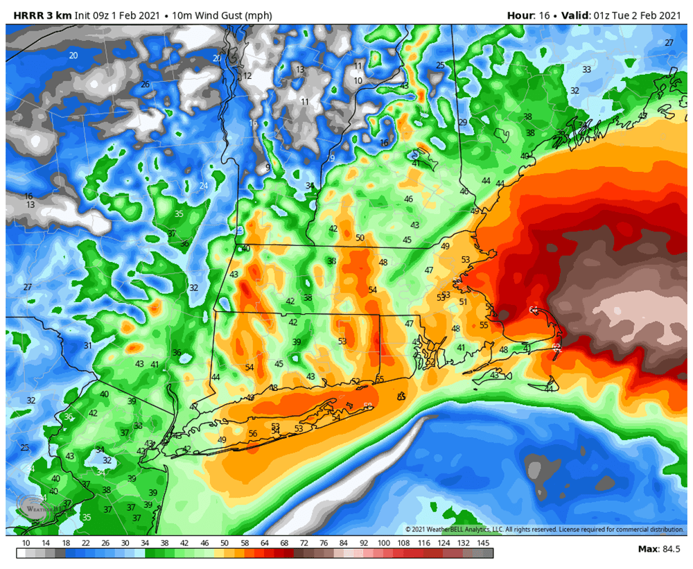
At the same time, warmer air is going to start to come in off the ocean. The western extent of this warm air will determine how much snow the coastline receives. If you look at the snowfall map above, you're going to see a very tight gradient going from a coating on the outer tip of Cape Ann all the way up to a foot not too far to the west.
This level of specificity is almost impossible to predict, so those of you who live right at the coastline — within about 5 to 10 miles — should be prepared that this band could move a bit either way.
The snow will be heaviest between 11 a.m. and 6 p.m. -- when rates could exceed 1 or 2 inches per hour.
During the middle part of the evening, the catalyst for the heavy snow will begin to move north of the region and you'll notice it start to taper off. It may just end up being a little bit of freezing drizzle or light rain or snow for many of us after 10 p.m.
I highly recommend trying to clean up before you go to bed as much as possible because the snow will just get heavier and wetter as the night goes on.
Winds will be picking up late this morning and peak between 4 p.m. and midnight. Eventually, the winds will start to slack in as the low pressure area pulls into the Gulf of Maine. The wind and the heavy snow will likely be enough to create some power outages.
The weather continues to be unsettled Tuesday with periods of rain and snow. There could be some additional very light snow accumulation in the afternoon as the storm intensifies to our north and east. Thereafter, seasonable temperatures in the 30s to around 40 are expected for Wednesday and Thursday, with the most sunshine by Thursday.
"much" - Google News
February 01, 2021 at 06:48PM
https://ift.tt/2LdArgI
Here's How Much Snow To Expect Monday As Nor'Easter Moves Through Region - WBUR
"much" - Google News
https://ift.tt/37eLLij
Shoes Man Tutorial
Pos News Update
Meme Update
Korean Entertainment News
Japan News Update
Bagikan Berita Ini


0 Response to "Here's How Much Snow To Expect Monday As Nor'Easter Moves Through Region - WBUR"
Post a Comment