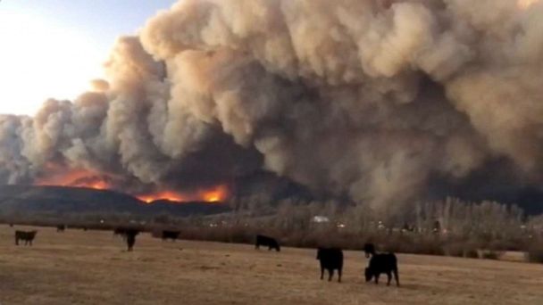
In Colorado, the East Troublesome fire is now at least 188,000 acres and is still only 4% contained. The good news is that snow is beginning to move into Colorado this morning and should help put an end to the weather conditions that have been fueling the record breaking fires there.
Unfortunately, much of Colorado is in an extreme to exceptional drought and that will not be resolved by one snowstorm.
Attention also turns to California where extremely critical fire conditions are expected to arrive beginning later Sunday and last into early Tuesday.
A significant offshore wind even will develop in parts of southern Oregon and into nearly all of California today.
Winds could gust well over 70 mph in areas and humidity could be as low as 5% which could result in easy fire starts, rapid spread and erratic fire behavior.
This could be a very significant fire weather set up, especially for the Bay Area and into parts of Northern California.
The National Weather Service in Sacramento is highlighting that this setup is similar to fire weather events in late October 2019 and early November 2018.
The most damaging winds are expected late Sunday and early Monday across parts of the Bay Area and Sacramento Valley.
In addition to the potential for fires, there is potential for downed trees and power lines as well.
The Los Angeles area also is going to see dangerous fire conditions beginning tonight and into Monday.
Winds in the Southern California mountains could gust as high as 80 mph and fires that develop in Los Angeles and Ventura County could also become quite erratic and rapidly spread.
East of the fire threat region, a big push of very cold air, as well as a snowstorm, is surging into the Rockies and Plains.
The storm already has brought up to 20 inches of snow in parts of Montana and, this morning, snow is moving through parts of Wyoming and Colorado, as well as parts of Nebraska and South Dakota.
The storm is expected to continue to push southward through the next 24 to 48 hours and snow will move into parts of Kansas, western Oklahoma, the Texas Panhandle and New Mexico.
Additionally, precipitation is going to be mixed from Midland to Kansas City on Monday going into Monday Night which could result in some Ice Accumulation in the Southern Plains.
Locally, over a foot of snow will be possible in the Rocky Mountains and into some parts of the southern High plains where there could be a wide area of 3 to 6 inches of snow from Western Texas to Western Nebraska.
The cold air moving in behind is significant as widespread record low temperatures are possible today across the Northwest.
By tomorrow, we could have record lows across a huge section of the country from California to Wisconsin.
Wind chills tomorrow morning could be in the negative teens across the northern plains and northern Rockies with cities like Denver expecting a wind chill of -6 expected tomorrow and Minneapolis expecting a wind chill of 6 - incredibly cold by October Standards.
It is possible that by Tuesday we will see over 100 daily temperature records across the region.
Unfortunately, the turbulent weather doesn't end there.
Tropical Storm Zeta, the 27th named storm of the season is meandering over the Caribbean this morning.
The storm is located 295 miles Southeast of Cozumel Mexico and is barely moving north at 1 mph.
Tropical storm watches and warnings have been issued for parts of Mexico and Cuba as heavy rain and gusty winds are expected in the coming days.
Zeta is the 27th named storm of 2020 Atlantic Hurricane season and is the earliest 27th named storm on record.
Zeta is expected to continue to organize and move towards the Yucatan peninsula by late Monday into early Tuesday.
When Zeta emerges into the Gulf of Mexico, there will be a brief window for strengthening and the current forecast has Zeta reaching hurricane strength by Tuesday.
The current forecast is showing Zeta likely reaching the Gulf Coast as a Tropical Storm by the middle of the week.
Unfortunately, computer guidance wants to take Zeta towards Louisiana, which has already been hit by Laura, Delta, Cristobal, and Marco.
All of the ingredients, including a punch of cold air, a storm system and tropical moisture will likely bring some form of impactful weather to the northeast U.S. by the end of the week.
Copyright © 2020 ABC News Internet Ventures.
"much" - Google News
October 25, 2020 at 06:18PM
https://ift.tt/2Hxb4o9
Turbulent week of weather is ahead for much of the country - WTVD-TV
"much" - Google News
https://ift.tt/37eLLij
Shoes Man Tutorial
Pos News Update
Meme Update
Korean Entertainment News
Japan News Update
Bagikan Berita Ini


0 Response to "Turbulent week of weather is ahead for much of the country - WTVD-TV"
Post a Comment