A severe thunderstorm watch is in place for much of New England Wednesday afternoon and evening as storms threaten the region. Flash flood warnings are in place in parts of Connecticut and New Hampshire and severe thunderstorm warnings are in place in parts of New Hampshire, Vermont and Maine as well.
See severe weather alerts for your area.
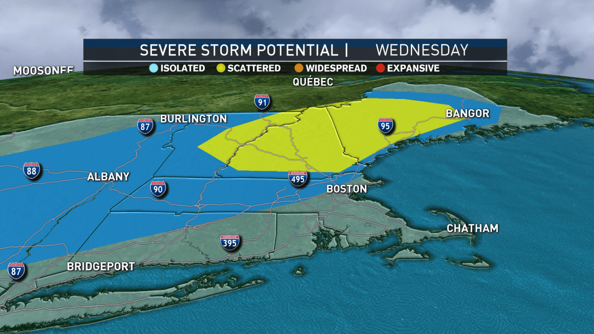
The severe thunderstorm watch, in place through 10 p.m., covers all of New Hampshire and Vermont, as well as western and central Maine and the region's coastal waters. The National Weather Service is warning of wind gusts up to 70 mph and hail that can reach 1.5 inches across.
The threat of thunderstorms is being caused by a hot and humid air-mass that's back in New England for the foreseeable future. Of course some days, the threat is greater than others, and Wednesday has a high threat.
For that reason a First Alert continues in New England this afternoon through evening with strong thunderstorms expected.
These thunderstorms will drop heavy rainfall in a moisture-laden air, feeding off increasing humidity that’s delivering clouds stubbornly breaking for sun, a few light showers at times this morning and early afternoon and an increasingly sultry air.
Some storms will grow strong enough for locally damaging wind and perhaps hailstones at their center, while an isolated tornado can’t be entirely ruled out in the northern half of New England, including southern Maine.
For many of us who see thunderstorms – regardless of whether they meet the criteria of a severe storm with damaging wind and hail – not only will we see heavy downpours capable of localized flooding, but also frequent cloud-to-ground lightning.
The storms diminish and/or move offshore Wednesday evening for partial clearing and areas of fog overnight with lows only in the 70s for most.
The threat for storms is low Thursday. Just a few spot storms with sun and clouds and high temperatures pushing to 90 degrees, with dew point temperatures around 70 degrees. That creates heat index values (“feels like” temperatures) over 90 degrees for a steam bath feeling.
Download our free mobile app for iOS or Android to get the latest breaking news and in-depth coverage of COVID-19.
Friday into Saturday is the focus of our team’s next First Alert, for a developing storm along the Mid-Atlantic coast. Spinning up over the warm waters of the Gulf Stream – the warm ocean current that parallels the East Coast – the National Hurricane Center pins this storm with a 70% chance of becoming a Tropical Depression or Tropical Storm Fay, and our team is forecasting it to move north to New England.
Though the exact track and strength are to be determined, we know a period of increased downpours, thunderstorms and gusty wind is a distinct possibility from late Friday into early or midday Saturday – we’ll fine tune details as we draw closer.
The system is expected to continue trucking northeast Saturday evening, returning New England to heat, humidity and scattered afternoon thunder for Sunday.
Our mid-summer pattern rolls on through next week in our exclusive First Alert 10-day forecast.
"much" - Google News
July 09, 2020 at 01:21AM
https://ift.tt/3ebnRXF
First Alert Weather: Severe Thunderstorm Watch Covers Much of New England - NBC10 Boston
"much" - Google News
https://ift.tt/37eLLij
Shoes Man Tutorial
Pos News Update
Meme Update
Korean Entertainment News
Japan News Update
Bagikan Berita Ini


0 Response to "First Alert Weather: Severe Thunderstorm Watch Covers Much of New England - NBC10 Boston"
Post a Comment